AccuWeather Predicts On-time Frost Will Hurt Corn, Soybeans
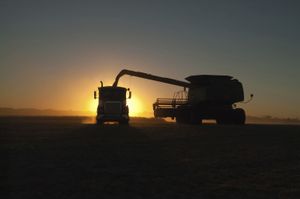
Harvest
Corn and soybean crops, especially in the northern part of the Midwest, are still a week or two behind normal maturity thanks to delayed planting and a cool, wet growing season. That is making the upcoming harvest a race to getting the crop mature before the first frost hits.
And frost just may win the race, according to Dale Mohler, senior commodity weather forecaster with AccuWeather.
“We are not projecting an early frost, but there are signals that we will get a normal first freeze date in the upper Midwest. That would be late September or early October in the Dakotas and Minnesota,” he says. “We are seeing signs that we are going to see a little more tilt of the flow to the northwest, and that will be favorable to pull chilly area down out of Canada and into the Midwest at just about that normal first freeze date.”
The problem is there are a lot of corn and soybean acres that need a late frost to make full maturity, according to Mohler. That means a drop in the corn and soybean production, both in terms of quantity and quality because plants will quit filling grain and start drying down, he says. That reduces the size of seed, which in turn reduces yield.
2019 yield predictions
AccuWeather analysts predict the 2019 corn yield will be 13.53 billion bushels compared to 14.42 billion in 2018, while the soybean yield will be 3.610 billion bushels compared to 4.543 billion bushels in 2018.
It would be the lowest corn yield since 2012, a year of significant drought that saw corn production numbers fall to 10.76 billion bushels. It would also be the smallest soybean yield since 2013 (3.357 billion bushels). AccuWeather predicts an 8% drop in soybean bushels per acre from 2018 and a 5.4% drop in corn bushels per acre.
Mohler said the upper Midwest has had a cooler than normal early September, which has slowed corn and soybeans from maturing, while Kansas has been several degrees above normal temperatures pushing crops toward maturity. In the southern and central part of the state, corn harvest was underway by mid-September.
A southwest flow pushing hot air from Texas into Kansas has been responsible for that. But, he said, it appears a different pattern that may bring a “right on time” frost to the upper Midwest will also bring some cooling to the central and southern Plains.
When it comes to the coming winter, the forecast gets a little trickier, he said.
Part of the reason for that is that the El Niño Southern Oscillation is neutral and expected to stay that way through the winter.
“That means that there is no impact from an El Niño or a La Niña and we have to look at other things to try to predict what will end up being a driver.”
Complicating the picture more is the fact that some of those “other things” are in conflict — some indicate a colder winter and some a warmer winter.
“I think at this point, it looks like we may see a colder than normal winter in the northern half of the corn belt but for Kansas, the prediction is right around normal temperatures,” Mohler says.
He added that moving away from the El Niño that was in effect last year will likely mean less rainfall than last year’s extremely wet conditions but not necessarily the drought that often marks a La Niña event in Kansas.
Changing factors
Of course, some of the indicators that provide the data that is fed into computer modeling — things such as position and size of abnormally warm or cool sea surface temperature pools — could change.
“We don’t have nearly as robust of a data set that goes into the long-range forecast as we do the short -range,” he said. “For the short-range, we input data collected from the surface up to six or eight miles into the atmosphere in layers. That makes the short-range forecast more accurate, but unfortunately, we don’t have computers powerful enough to look at that much data to provide a long-range forecast. Absent that vertical data, the prediction is a little less accurate.”
Another tool that forecasters use is analogs. This compares the weather experienced in previous years, which had similar conditions as ones expected in the coming months. Analogs are currently not included in short range or long range computer forecasts.
The likelihood of another winter of brutal weather (think bombogenesis) is not high, Mohler says.
“I think that’s likely a 50-year event. It’s not unprecedented, but neither is it common,” he says. “That event was triggered by a storm that intensified rapidly. That happens a lot more over water than over land where you may have very warm water but colder air aloft.”
What scientists are studying now to try to predict just what might emerge as a major factor in steering the direction of storms is the surface temperature of waters in the Atlantic and Pacific.
Both are warmer than normal over a very wide area.
Those warm waters contribute to the upper air steering currents that that determine the path storms make take.
Warmer oceans also tend to mean generally wetter conditions while cooling waters tend to mean more droughts, Mohler says.
The severity of storms that develop is another thing that is difficult to predict in the long term. In the short term, however, forecasters look at the observations of where there is warm air at the surface and cool air aloft and where there is the most contrast between surface and aloft. The more the contrast, the likelier development of severe storms.