Dry Conditions Continue to Spread
According to the June 23, 2020, U.S. Drought Monitor, moderate to extreme drought covers 21.4% of the United States including Puerto Rico, an increase from last week’s 19.6%. The worst drought categories (extreme to exceptional drought) stayed the same as last week: 1.9%.
Precipitation fell across much of the northern tier states and the eastern half of the CONUS this week. Much of the eastern United States has experienced increased dryness over the past 30-60 days and above normal temperatures. The heaviest rains missed many of the D0 and adjacent areas, warranting D0 expansion for several locations in the eastern CONUS. The Northeast (New York to New England) has seen conditions drastically deteriorate this week. Agricultural impacts are being reported across many areas in New England, particularly Maine, and 7-day USGS streamflows are below the 10th percentile for much of the Northeast Region. Areas just east of the Rockies missed out on some of the heavier precipitation this week, which fell over central Kansas, central Oklahoma, and northern Texas. This allowed for some improvement, mainly in areas that with D0 and D1 designations at the start of the week. However, severe (D2) and extreme (D3) drought designations remained for many locations in the Texas and Oklahoma Panhandles, eastern New Mexico and Colorado, and western Kansas. Mixed improvements and degradation in the northern Rockies and High Plains.
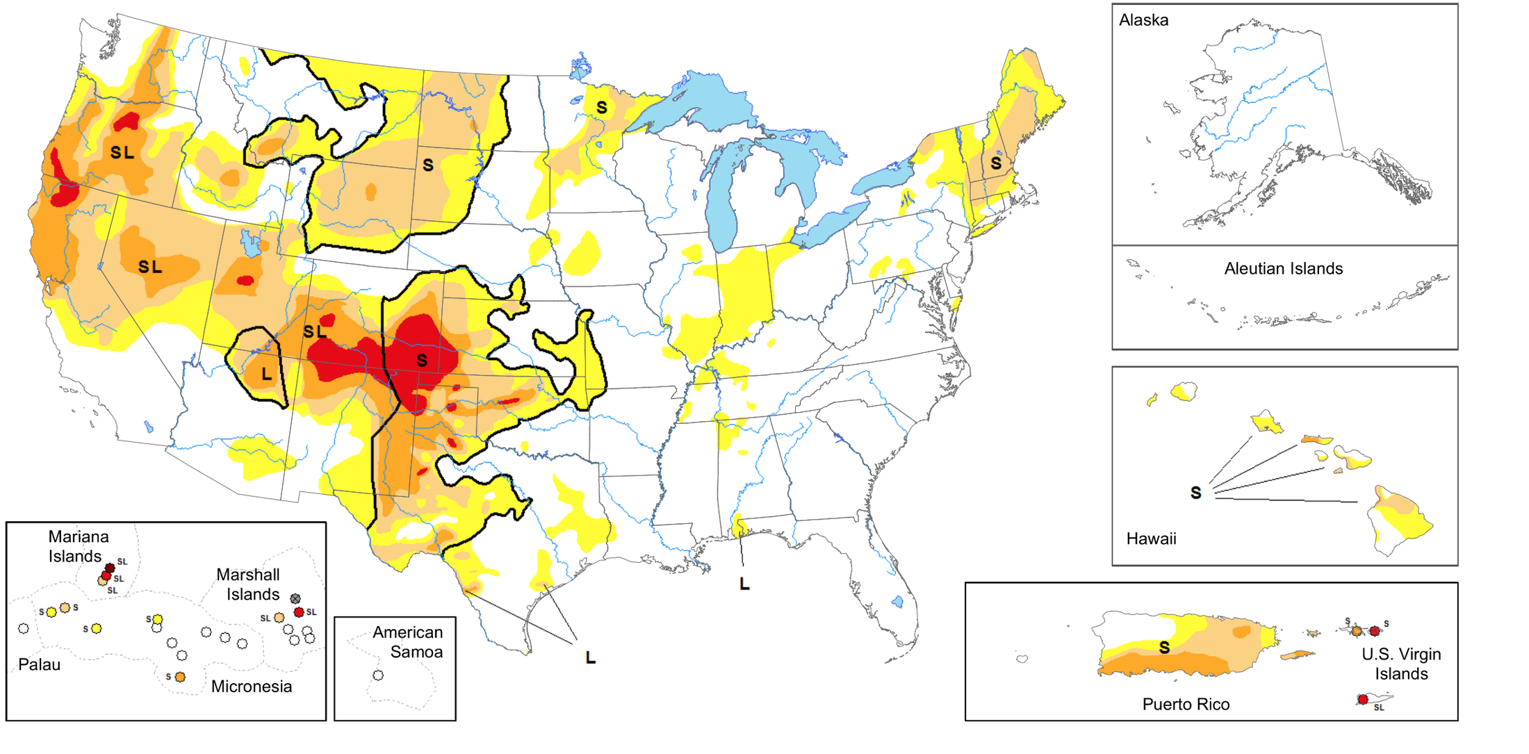
The Northeast has experienced a dry pattern for in the past 30-60 days. Much of the region from New York to Maine received little to no rainfall this week and experienced temperatures well above normal. D0 was expanded to include all of Maine, portions of central and southern New York, and southwestern Connecticut. D1 was introduced to a large portion of southern New England extending into eastern New York. D1 was also introduced in northeastern Maine and Saint Lawrence County, New York. Many of these areas have received 25-50 percent of normal precipitation over the past 30 days (D0 and D1 areas) and over the past 60 days (D1 areas). D2-D4 equivalent SPIs are widespread across areas with D1 coverage, 7-day USGS streamflows are much below normal (below the 10th percentile), and current CPC soil moisture is between the 10th and 20th percentiles for much of the region. Parts of northern Saint Lawrence County, New York reported their driest April 1 – June 22 period on record. There have been some reports of corn rolling in some areas in New England. Maine in particular is seeing elevated impacts due to well above normal temperatures and lack of moisture in recent months, in addition to freezes in early- to mid-May. This has resulted in reduced spring grain yields and there are reported concerns about potential irrigation limitations. Farther southwest (Pennsylvania southward), a cutoff low over the eastern CONUS early in the week, followed by the passage of a frontal boundary later in the week, brought decent precipitation amounts to southern areas of the Northeast (1-2 inches, with locally higher amounts). This warranted some minor D0 removal in southern Pennsylvania and north-central Maryland.
Heavy rain fell over parts of Virginia and North Carolina, with several locations receiving an estimated 4-8 inches of rainfall (and localized higher amounts), in association with a cutoff low early in the week. The rest of the Southeast saw near to below normal precipitation, warranting some D0 expansion and introduction in northern Alabama, as the precipitation was not enough to overcome short-term dryness (25-65 percent of normal precipitation in the past 60 days). A few streamflow gauges are also registering below normal streamflows the past 7 days in northern and western portions of Alabama. Further south, the central Gulf Coast received enough precipitation this week to warrant D0 and D1 removal over portions of southern Alabama and the western Florida Panhandle. However, more is needed as year-to-date (YTD) precipitation is still 65-75 percent of normal for areas with continued D0 coverage and 7-day USGS streamflows below normal (10th-24th percentile), and in a couple cases much below normal (below the 10th percentile).
South-central Oklahoma and northern Texas saw very heavy precipitation this week (4-8 inches). However, accumulations were lacking a bit in areas with D2 and D3 designations. Above-normal temperatures, high wind events, and below-normal precipitation leading up to this week has led to high evapotranspiration rates and hardened soils, increasing runoff. So more rainfall over extended periods is needed for improvement in some of the driest areas in the Central and Southern Plains. Elsewhere in the Southern Region, 30-60 day deficits continue to be the headliner. Although much of the region saw precipitation, many D0 and adjacent areas saw near to below normal rainfall, warranting some D0 expansion in the Tennessee Valley and eastern Texas.
The Midwest saw widespread precipitation this week, with the heaviest rain falling in eastern Iowa and across central Wisconsin. Some minor D0 removal in western Iowa, corresponding to areas receiving 1.5-3 inches of rainfall. Some trimming of D0 and D1 in central Minnesota was also warranted, with the area receiving more than 1.5 inches of rainfall. However, D0 was expanded in eastern Minnesota into Pine and southern Carlton Counties, which received little to no rainfall this week. SPIs continue to remain negative (below -1.6 at 30 and 60 days; i.e. D3 and D4) and USGS 7-day average streamflows have fallen below the 10th percentile for these counties. Across the Corn Belt, the heaviest rainfall avoided many D0 and adjacent areas. For locations that did see precipitation, it was near to below normal for the 7-day period. As such, 30-60 day deficits continue to mount, warranting some D0 expansion into some of the drier locations this week. USGS streamflows are also continuing to fall below normal (10th-20th percentile), especially across Indiana.
Similar to the Southern and Central Plains, many areas in the High Plains Region have fallen victim to above-normal temperatures, high winds, and a lack of precipitation in recent weeks. Some reduction in drought coverage in areas receiving the heaviest precipitation throughout the region, most notably central Kansas where many areas received 2-6 inches of rainfall. However, elsewhere 30 and 60 day deficits continue to increase, corresponding with D2-D4 equivalent SPIs and 25-50 percent of normal precipitation over the past 30 days across most areas depicted in drought. Soil moisture also continues to suffer across western North Dakota, much of Wyoming, and all of Colorado (CPC showing soil moisture below the 5th percentile for much of Colorado). There have been reports of low reservoir levels in North Dakota. Colorado has reported several episodes of 100-degree days in the southeast portion of the state in recent weeks, as well as cattle being sold and failing winter wheat crops. As such, severe drought (D3) is status quo this week for southern and southeastern Colorado.
Much of the West remains status quo this week. Montana saw the most change, as 7-day rainfall accumulations over 1 inch were able to dig into some of the short-term departures, mainly in D0 areas. However, extreme eastern Montana missed out on rainfall this week. YTD SPIs are less than -2 in Richland County and USGS 7-day average streamflows are below normal (10th-24th percentile) near and just over the North Dakota/Montana state line, which warranted some D1 introduction there.
Alaska, Hawaii, and Puerto Rico
In Alaska, there is some dryness evident over various periods for a few locations on the Kenai and Alaska Peninsulas, but nothing to warrant any D0 introduction at this time. In Hawaii, small areas of D1 and D0 were introduced in southern and northeastern Kauai, respectively, in favor of NDVI and 7-day precipitation accumulations. SPIs in nearby locations also show dryness at 30 days. Puerto Rico saw its heaviest precipitation in the northwest (3-5 inches), which warranted only slight reduction in D0 coverage on the western coast of the island. Modest rainfall amounts were observed in southeastern Puerto Rico and were below normal (1-2 inch negative anomalies) for the week, bringing 30-day deficits to 4-8 inches and warranting the expansion of moderate drought (D1) to the southeast coast.
Source: Drought Monitor