Rains Force Corps Response
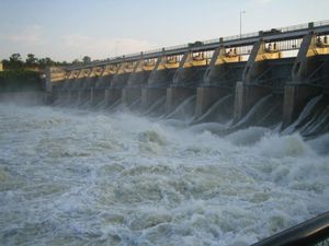 Heavy rains over the past two weeks in the upper Plains are prompting the U.S. Army Corps of Engineers to first reduce water releases into the Missouri River from Gavins Point Dam in South Dakota, then increase the volume of water flowing out of the dam.
The Corps of Engineers indicated concern that floodwaters could again overwhelm lowland areas in Iowa west of Interstate 29. The Corps cited that rainfall over the past two weeks has been 200% to 600% of normal throughout the entire Missouri River Basin.
Over the past two weeks, Montana, North Dakota and South Dakota have recorded heavy rainfall totals. In just the past few days, several cities in South Dakota were hit with rain totals of more than 7 inches, causing widespread flooding across the southeastern corner of the state, Associated Press reported. Some tributaries to the Missouri River again approached or topped record flood stages.
In response, the Corps stated it will reduce releases from Gavins Point Dam, which have been at 70,000 cubic feet per second or higher since spring. The Corps stated it will reduce releases by 5,000 cfs on Saturday, Sept. 14, and reduce releases another 5,000 cfs on Sunday as well. The main reason for lowering flows is to reduce the risk of floodwater reaching Interstate 29 north of Omaha, said John Remus, chief of the Corps’ Missouri River Basin Water Management Division.
The Corps stated that releases will drop 60,000 cfs from Gavins Point for no longer than three days. Then, the Corps will incrementally increase the flows 5,000 cfs per day until the flows reach 80,000 cfs by Sept 21. That will translate to just about 600,000 gallons of water flow per second.
The increased releases will keep the series of Upper Missouri River dams holding at 16.3 million acre feet of flood storage that will be available for the 2020 runoff season, the Corps stated.
“We have already seen four times the normal precipitation for September over the entire Upper Missouri River Basin,” Remus said.
The Missouri River has been above flood stage since March 13. As of Sept. 13, runoff from the Upper Missouri River north of Sioux City, Iowa, has reached 49.9 million acre feet, topping runoff from 1997. As of now, 2019 runoff is the second highest in 121 years of records, behind only 2011, when 61 MAF was recorded.
As of now, the Corps estimates total runoff from the Missouri River will be 58.8 MAF. But in just the last two weeks, the Corps has had to raise its estimates by about 4.2 MAF.
Chris Clayton can be reached at Chris.Clayton@dtn.com
Follow him on Twitter @ChrisClaytonDTN
Source: Chris Clayton, DTN